Spicers Cove (Cape Chignecto - Nova Scotia)
On Friday August 5th, the Fundy Geological Museum organized a curatorial walk of Spicers Cove, located in the West Apple River area, North of Cape Chignecto Provincial Park. From Parrsboro its takes about 45 minutes or less to get there, or a little less than 2 hours from Moncton.
Here's the description of the curatorial walk from the FGM's website:
At Spicers Cove, walk through a Coal Age fossil forest; see volcanic flows, spectacular faults, igneous dykes, raised beaches, sea stacks, seals and sea ducks.
- FGM Curatorial Walks

I left from Moncton at about 8am and arrived at the Parrsboro Museum close to 9:30am.

Fundy Geological Museum (Parrsboro, Nova Scotia)
When I got there the doors were still closed, so I took the time to snoop around at the boulders and rocks on display outside the Center.
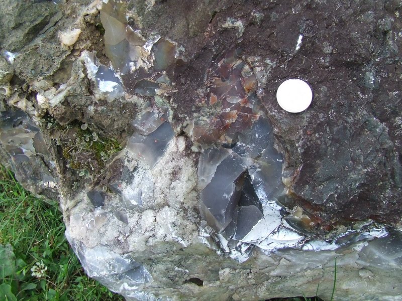
Rock containing agate


Porous rock containing marine fossils
From there we left and made a quick stop to Cape Chignecto Provincial Park's information center for using the restrooms and meet with the rest of the tour attendees. I was told that this was one of the most popular walks.

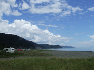
Spicers Cove
Getting to Spicers Cove is basically driving on a 10km dirt road crisscrossing the landscape, avoiding water holes and crossing 1-lane bridges. With a large group like we had that day, which numbered close to 40 people, the train was a tad slow but we eventually got there.

When we left Parrsboro it was still cloudy and the rain showered sparsely, but by the time we arrived at Spicers Cove, the Sun had started to peak through the clouds. The group proceeded to walk to a location designated by Ken Adams, so that we could then walk back before the tide would be too high. Walking to our destination we saw distinctively two different sections of rocks. Closer to the entrance you have coal age carboniferous outcrops baring fossils, and walking further south the scenery changes and you have these great red rhyolite cliffs.


Here Ken is indicating the major fault and the direction the formation(s) moved and flexed during the coming together of the supercontinent Pangea. The forces pushed and pulled, affecting the topography by moving plates and changing the landscape. Sections were pushed upward, some sank deep, and with the pulling and tugging lava flow intruded in the fissures in the rock by this colossal tug-o-war.

As the landscape was pulled apart, gaps and fissures appeared. Lava from deeper in the Earth would come and fill in these gaps with, shown in the above as the dark mineral. These volcanic dikes form these dark wedges and fingers in the cliffs, standing out.

Volcanic dike

On our way to our destination

The beach at Spicers Cove is a composite of rocks weathered from the local cliffs or from other locations transported either by water or ancient glaciers. You can also find somewhat the same type of beach gravel on top of the cliffs (grey margin, top center), an indication that the beach was at that height at one point in the past.


Dike

The picture above shows multiple dikes in the cliffs. When the continents was being ripped apart, volcanic material would have filled these fractures in the rock, leaving this dark mineral behind. With time, the mineral that make up these dikes weather away, leaving rock features that often look like fingers (such as the Three Sisters in this area).

Andersons Cove


After the darker mineral type rock weathers over time, the only thing left standing are the harder red rhyolite rock, creating features such as the one in the picture above.


Bary(i)te (?)

Conglomerate containing all sorts of crystals and minerals


Further North of these red cliffs are outcrops of greyish shale that contain fossils, but I was told that these could possibly also contain some. One scenario I imagine is the sediments from a valley being carried by rivers, dragging plant material and animal bones along with it. The fossils could be contained in the sedimentary red layers (like the layer of conglomerate-like rock perpendicular to the person standing in the picture above).


Fault separating two rock formations, representing a gap of quite a few million years (up to 50 Ma if I recall). The color of the rock on the left of the gap is different from the rock shown at the bottom right of the picture above.

Carboniferous Age rock outcrops

Stigmaria, roots from lycopsid tree family

'Bark' from lycopsid tree, possibly Sigillaria

Citrine (?)

Mudstone containing fossils. The different colors in the mudstone indicate a change in the environment when they were deposited, such as oxygen. On top of that is a thick strat of sandstone.

Slip fault
The strata in the picture above shows the fault slip (probably as a normal fault) when one section has moved in opposite direction than the other section. The above strats show a slip of a few meters, as the mudstone strat on the left would have originally be aligned with the mudstone layer on the right.

Calamites with extension in cross-section (Asterophyllites(?))
The outcrops are rich in fossil material and surprisingly very well preserved even with the strong action of the local tides of the Bay of Fundy. The scenery is spectacular and the cliffs are an amazing sight to see. The road to get there isn't too bad as you can either come from Parrsboro or from Joggins via Shulie road. There are other areas that I'm sure are equally interesting to check, but I will definitly come back.
Till next time!
Disclaimer: In Nova Scotia under the 'Special Places Protection Act', fossils cannot be dug up or disturbed without a permit. The province has a mandate to protect palaeontological sites and it is your civic duty to report any finds to the local museum, or the Department of Communities, Culture and Heritage (https://cch.novascotia.ca/exploring-our-past/special-places). This encourages the contribution these finds could make to science not just in the provice, but on the global stage. You must also seek permission if you are to enter private land.

Comments
Post a Comment