In Alma, All I See Is Red
I had the Friday off (May 18th) before the long weekend of May. It sucked that I had to work the long weekend, but knew that I'd have plenty of time off coming up. So being stuck at work during the nice, long weekend wasn't too bad to bare. I wasn't planning to do too much that day, so I moped around the house for a bit. I was getting bored out of my mind and needed to get out of the house, so I decided to hop in my car at around 2pm and go for a drive. At first I didn't plan to go too far, but I found myself driving from Riverview towards Hillsborough.
By the time I stopped driving, I was pulling in the Fundy Park Info Center parking lot. I said to myself, might as well go in and check the boutique. Bought a few goodies and went back in town.

I decided to stop at the Tides Restaurant in Alma for an early supper. They usually open for the season during the long weekend, but ended up opening early for Mother's Day. I can say that the food here is freakin good and the view is awesome. Depending on the tide, you can see the boats move around at high tide, or people walking at low tide on the beach where those same boats would have been.

I always go for the herbed chicken. So good! The restaurant also has an outdoor patio where the menu is a little different. I had room for dessert, so I asked if they had anything new on their menu. The waitress mentioned a new vanilla and salty caramel cake. I jumped on the occasion and let me tell you, that cake didn't last long on my plate. The chocolate desserts she had showed me earlier looked good, but man that cake topped it. Didn't even have the time to take a photo of it, it was already long gone!
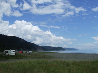
I looked at my watch and it wasn't 5pm yet, and we were smack in the middle of low tide. Since it was so nice out, I drove my car and parked at the old rink, and walked down the path by the Alma fishmarket and to the beach.

I've been here before but haven't walked real far. The sand stone in this area is mostly medium size grain to coarse, buff colored, and full of plant material. There are numerous layers of bio-rich plant bearing mudstone, and a shit load of channel bodies.

Dark, greyish band is rich in biomass

The buff colored sandstone is littered with plants (orange)

Channels, different deposition

Calamites (left extremity bending down and tapered)


Minor fault (?), minor displacement

Big arse channel, with alternating depositional sediments
I didn't bring my normal tools with me or my camera, so I took those pics with my blackberry phone, which was about to croak on me. I was taking pics and checking the sandstone at my feet when I noticed this on the horizon:

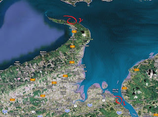
The foreground shows the typical buff colored sandstone cliffs you'd see from Alma to this location (albeit hard to see in this picture is the incline change of the strata). In the background, you get these purple-reddish cliffs, with another smaller section that's popping a shade redder. I WAS gonna turn around and head back to town, but when I saw that, that peeked my interest. I knew that from the other side near Dennis Beach near Cape Enrage you'd get red Triassic sandstone and/or conglomerates (quartzite), but from reading New Brunswick topo maps and actually being on site, something just doesn't jive.

Red arrow indicates area of interest
('bout 1.4Km from Alma)
N 45 36' 21.31
W 64 54' 43.59

From the coordinates I've indicated above, the split (middle right of photo) seperates two formations that couldn't be more topographically different. For this blog's purposes, I'll call it a fault (Major? I know there's the Harvey-Hopewell Fault that strikes and dips at a different direction) for the sake of being different, right? The base of the 'fault' lies a talus pile, a somewhat heap of rock. On the left side (using the picture as orientation) of the talus pile are layers (or strata) of red to dark brown sandstone that strike at a different angle than the buff or tan colored sandstone from the ones West of this spot. The sandstone contains from what I could tell at the time paleosol, with distinct features on the surface of the stratum. This red sandstone here only forms a tight, small triangular wedge between the purple-reddish rock on the right of the 'fault', and the buff 'Boss Point' buff to tan sandstone on the left. If you walk a couple of hundred feet West from that spot, you'll notice that the layers of sandstone are flipped to an almost vertical position and very distorted. These sandstone also contain plant rich grey mudstones several feet in thickness.
On the right of the talus pile, including this heap of loose stuff, is this purple-red metamorphic looking stuff. At quick glance it looked like rhyolitic metamorphic stuff. Second pair of eyes that looked at my samples I brought from this area suggested a more hetatite-ish composition. To add to this is that this stuff is what makes up these cliffs from here to way further East. I didn't venture further than Owl's Head, but I can tell you that the cliffs here are of the same stuff. I'm sure I'd find the same red sandstone from when first encountered, but I'd have to come back to walk all the way to Red Head, past Dennis Beach. I'm very familiar with Waterside Beach as I've done some recent work for my friend Matt, but not at all with Dennis Beach.

Ss - Sandstone I'm familiar with in the area. Selected in red are areas of future study


One of several waterfalls

At this point my Blackberry was dying on me. I managed to take a few more pics before it ran out of juice. The left portion of the picture above shows the buff sanstone, seen here as distorted and gnarled. The middle section is the red sandstone with distinctive layers. The right is the purple-reddish metamorphic looking stuff that make most of the neighboring cliffs seen in the immediate area East of this position.

Close-up of the red sandstone, showing different physical features
(last pic my phone took before kicking the bucket)

I've brought a few samples with me to have a closer look at them. The samples contained different type of minerals and possibly metals. Some of the pieces were quite heavy, some heavier than they looked.

I'm planning to go back very soon. I've got some vacation coming up and if weather permits, I'll be heading back down there for the day to get a better look, bring my tools, and my freakin' camera. My plan is to reach the other side of Owl's Head and see how far we get this type of rock, or even how they package up. I hope to be able to made some crude topo mapping of the area and jut up something to be able to play with after. I'm not convinced that what we see on the maps are what we're seeing on the field. We'll have to find out then, yeah?
Till next time!
Disclaimer: In New Brunswick under the 'Heritage Conservation Act', fossils discovered must not be destroyed or removed from sites where they are found without a permit. It is every one's civic duty to report any finds to the New Brunswick Museum (https://www.nbm-mnb.ca/). This encourages the contribution these finds could make to science not just in the province, but on the global stage. You must also seek permission if you are to enter private land.

Comments
Post a Comment