Somewhere in Parrsboro, there are trackways in the snow...
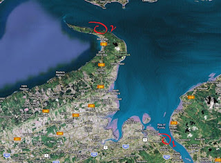
A few days ago I drew a map of the West Bay/Cape Sharp area South-West of the town of Parrsboro, Nova Scotia. I had wanted to check the Jurassic age basalt cliffs of Cape Sharp and poke around a bit to see if I could come out with anything. On the cliffs on each side of Cape Sharp are Carboniferous sandstone cliffs which displays a fascinating record of trackways, especially those of tetrapods. I had marked on my makeshift map where the location of a possible access point to the beach would be. If that wasn't the case, I had a plan B, set by driving back towards Parrsboro and finding an access point via Partridge Island.
I woke up Sunday (April 14th) morning and it was snowing. I said to myself: "Rain, Snow, or Shine, I'm heading down!". I hit the road at 7 that same morning. The temperature kept at about 0oC Celcius so the road conditions were pretty decent. The snow was melting as soon as it hit the pavement. I had checked the forecast the night before and they had called for higher temperature and a break in late morning. That was good enough for me.
I got to the road leading to the supposed beach access by driving a red, muddy, slippery road with my Rabbit. My car is usually gray, but not this morning after my trip down here. I parked the car, got my gear, and headed down the path.

Getting down the trail was somewhat annoying. Big trees had fallen at numerous spots and sometimes that meant I had to crawl in the mud or hop on the logs. I'm barely 5'2", so yeah it wasn't a pretty picture.

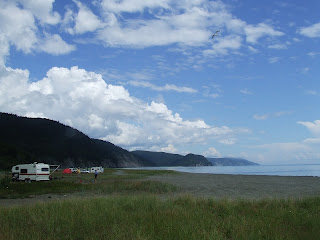
Cape Sharp behind the snowy haze
I got to the ledge of the cliff and there was somewhat of a 'trail' going down. It zigzagged a bit but the last 15 feet were just muck and loose sediment. I don't think that if I went down I could get myself back up. I tested the trail halfway and tried going back up. The face of the cliff was so loose and slippery that it took every ounce of strength in me to make it back up. There was no other spots to go down so, defeated, I made my way back up the steep trail. I exerted myself trying to go up that I had to lie down for a few minutes, fighting waves of nausea. During that episode I somehow managed to gash my hand pretty good. Wet, muddy, and bloodied, I sat my sorry arse in the car and drove to Plan B.

West tip of Partridge Island
There was no way that this rock trip was gonna be in vain, so I found myself taking the beach road behind the Ottawa House down West Bay Road. Last time I was here was in 2011 so my memory was a little bit hazy. I drove down the sandy road and after dodging or ramming through some major olympic sized pools of water, I managed to park in a safe area.

Dirty rabbit!
The tides were coming back slowly so I had lots of time to stroll on the beach. Everything was wet so I was curious to see if I could still spot trackways with all the glare. Turns out after a few minutes that I could, and I managed to spot some old tracks and some new ones.

The cliffs are put at about Late Carboniferous, and are part of the Cumberland Group - Parrsboro Formation. The layers show an environment alternating between wet and arid, indicated by layers rich in river biota with surrounding vegetation, and the next indicating dryer conditions.


Mud crack features
The next few photos show a series of trackways and close ups of the ones I managed to spot.


Multiple sets of tracks


Tracks running horizontal

Set of tracks, evenly spaced, with drag mark running along the center

Close up of one of the indentation (from the previous photo)

No clue at the present of what this is
In a section that was protected from the elements, I took the time to take a closer look at some of the rippled surface and found some nice tiny tracks skipping on the surface. Each mes/pes are about ~1cm, running in several directions.


Folding where two major faults intersect. The rock is strained and the strate disappears under a thick mix of glacial till, only to reappear a few hundred feet further West. Some trackways to be found, but mostly deformed and barely identifiable.
This trip ended up being a very good one. I was able to get to see a few things I haven't seen before, and new data to incorporate in my ever evolving map of the area. Shows that its nice to prepare a litte in advance so that you're not left in a lurch.
To finish a good trip in Parrsboro, I had to stop at my friends place, Doug and Jackie's of course! Stayed a while and talked rock. I managed to get out of town with two gorgeous pieces to add to my ever increasing mineral collection. Here's their site: http://www.amethystboutique.com/
Disclaimer: In Nova Scotia under the 'Special Places Protection Act', fossils cannot be dug up or disturbed without a permit. The province has a mandate to protect palaeontological sites and it is your civic duty to report any finds to the local museum, or the Department of Communities, Culture and Heritage (https://cch.novascotia.ca/exploring-our-past/special-places). This encourages the contribution these finds could make to science not just in the provice, but on the global stage. You must also seek permission if you are to enter private land.

Comments
Post a Comment